


All literature can be downloaded here or picked up in town for FREE at the Welcome Center at 107 N 3rd St. Copies are also available at the Westcliffe and Silver Cliff Town Halls and the West Custer County Library.
Custer County Past & Present: A Historical Digest for Exploring the Wet Mountain Valley, a guidebook detailing the county’s fascinating history in timelines, images, stories, and more.
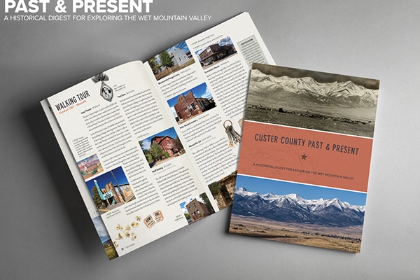
Download Past & Present
Watch The Wet Mountain Valley, a dark-skies timelapse video produced by award-winning SKYGLOW.
EVENTS
All Aboard Westcliffe ~ Spring Flea for All
Indoor flea market with something for everyone! Open to the public free on Friday, April 26th and Saturday, April 27th between 10am and 2pm. Vendor spaces are $25 per 8 foot table. Lunch and treats available. Held at the All Aboard Westcliffe Event Center, 110 Rosita Ave, Westcliffe, CO.
Free
Find out moreBeckwith Ranch Kids Day
The Custer County Kids Council, West Custer County Library, and Friends of Beckwith Ranch are teaming up for a great event for kids at Beckwith Ranch. Saturday, May 3rd from 10 AM to 2 PM, families are invited to Beckwith Ranch. Beckwith will open up all the buildings and provide docents (in 1890 period costume) to tell interesting real life ranching stories, answer questions,...
WCPA Live Theater ~ Treasure Island
Ahoy there! Set sail on a thrilling journey as the WCPA and Custer County High School present Treasure Island! Join young Jemima “Jim” Hawkins as she embarks on a daring quest for buried treasure; encountering treacherous pirates, hidden maps, and a legendary pirate with one leg. This swashbuckling adventure will keep you on the edge of your seat with its gripping storytelling, suspenseful twists,...
$15
Find out moreSangres Art Guild ~ 2025 Fine Art Calendar “Peace in the Valley” Show and Sale
An annual tradition in the Valley, The Sangres Art Guild Fine Art Calendar Show and Sale features all of the entries from the 2025 Calendar Art Competition, including the 13 winners selected by juror Gloria Countryman to be published in the 2025 Calendar – “Peace in the Valley.” Calendar Juror Gloria Countryman is an international award-winning artist, as well as a professional art critic....
Free
Find out moreSangres Art Guild ~ 2025 Calendar Show ~ Gallery Reception
“Peace in the Valley” The Sangres Art Guild returns to evening receptions with our “Peace in the Valley” - 2025 Calendar Show Reception on our 2024 Season 3rd Street Gallery opening day, May 4th, 2024. The Sangres Art Guild Fine Art Calendar Show and Sale features all of the entries from the 2025 Calendar Art Competition, including the 13 winners selected by juror Gloria...
Free
Find out moreLatest Articles
Travel Responsibly in the Wet Mountain Valley
The Wet Mountain Valley is a beautiful place, and we’d love for it to stay that way for generations to come. Whether you’re strolling downtown, hiking trails, or watching the stars, please help by traveling responsibly.